Difference between revisions of "Geofencing"
(Created page with "{{DISPLAYTITLE:GEOFENCING}} ==Overview & Basic Concepts== <br> : Users with admin rights (device owners/admins) can access the configuration from the lists and profiles using...") |
(No difference)
|
Revision as of 21:44, 3 October 2021
Overview & Basic Concepts
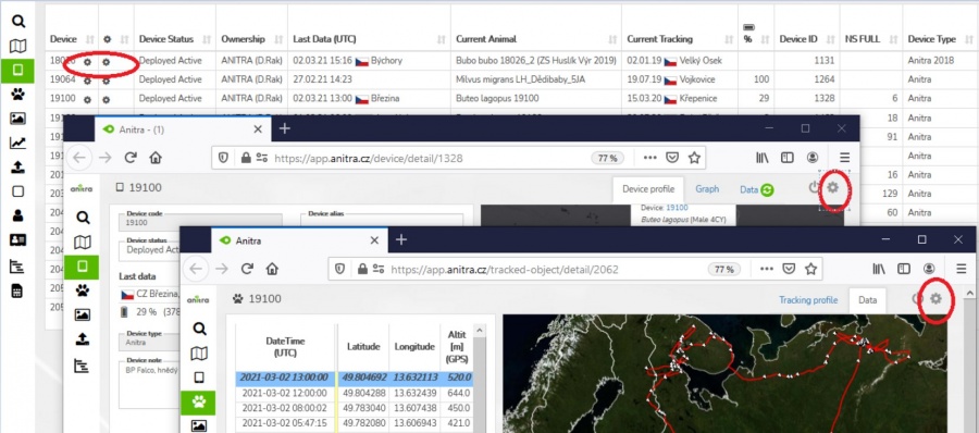
- Users with admin rights (device owners/admins) can access the configuration from the lists and profiles using cogwheel icons.
- Note the configuration functionality is available for Anitra devices only.

- User configuration screen is structured into three main areas
- Data collection settings
- Communication schedules
- Other settings
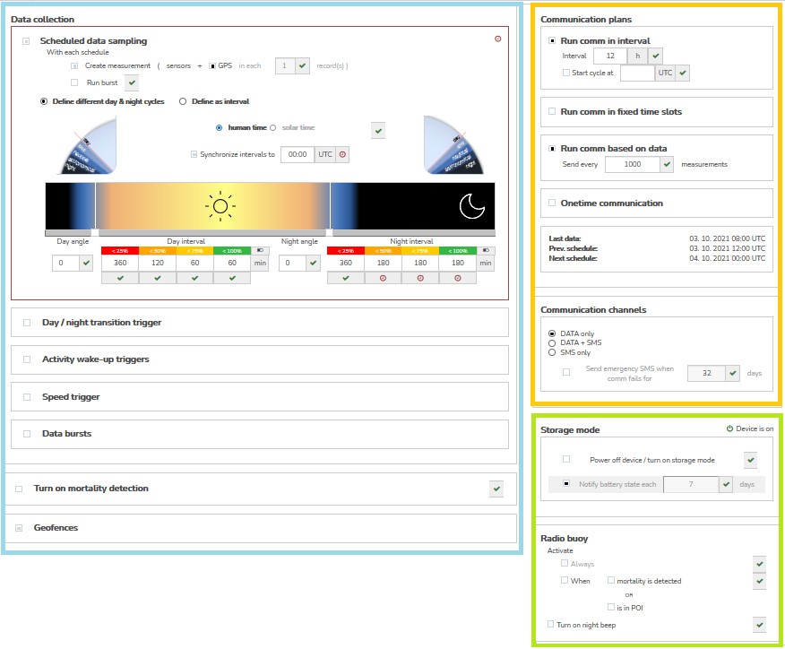

- Note many more advanced settings are possibly available to adjust device behavior upon request/need (device maintenance, troubleshooting, firmware upgrades, custom configuration/behavior - such as GPS accuracy, etc)
Modifies standard configuration definition when device enters the geogfence physicaly
Specifics of Anitra geofencing • Tailored for very advanced geofencing tasks on top of POI databases with even many thousands of items (e.g. database of pas poisoning places, windturbines, dangerous power pylons etc) • GF defined by circular (or possibly cylindrical) zones • Working with circles allows resolving conflicts for overlapping GF (as the closest, the smallest) • Altitude definition enables 3D geofencing (then higher it is considered as outside of geofence) • While moving the device synchronizes 100 closest geofence instances
GF creation
• For configuring geofences click the „geofences“ section in device configuration screen
o Note the geofencing functionality was significantly reshaped and only devices with device firmware updated to the latest versions can use this feature. If you do not see the „geofences“ section in your configuration screen plese consult us if your device can possibly use this functionality
• a dedicated screen showing list of geofences on the left side and map of those in the right
A new geogence created using „Add new geofence“ button
Geofence (GF) defintion consits of • spatial definition (Latitude, Longitude, Radius{range, and Altitude) • modified behavior configuration for the geofence
A spatial definition can be done in two ways • either manually in the map - „Define in the map“ option o set centre and drag a radius in the map o proceed to behavior definition • or using POI group – „Link to POI database“ option o list the existing POI group (note this requires you to have defined some POIs and POI groups previously – see the dedicated section of Anitra documentation o latitude and longitude defiitions are used from POIs in the group and you only need to define the radius valid for all the POIs o save and proceed to behavior definition
Behavior definition • a simplified configuration screen to manage geofence parameters is shown • currently valid configuration is displayed as a background • GF parameters overriding standard configuration can be set and saved • a similar editing logics as for standard configuration is implemented here – i.e draft modifications (blue) and already saved values (red) o get rid of any blue changes using blue crosses or simply closing the screen without saving the values o remove all red (saved) modifications using red crosses and resaving the screen
notes on navigation in existing geofences
• Select the GF in the left list of in the map to locate it in the map nad vice versa
• Geofences can have following states
o new: a geofence with spatial definition but no behavior defined yet
o inactive/disabled: a complete GF definition ready to be acivated, allows temporary disabling GF and reanabling later when neded
o active: only in this state the GF definition is actualy submitted to device !
• you can change the GF states using buttons („save“, „activate“, „disable“, „delete“) – a relevat buttons appear when clicking at the GF in the list
o save – saves modified definition
o activate – activates prepared definition and submits it to device in next communication session
• access GF edit mode double clicking the geofence in the left GF column
o you can manuály modify the original spatial definition retyping the values of latitude, Longitude, Radius or Altitude
o you can also custom name the geofence
o access behavior definition klicking a cog wheel icon
o use escape to close „edit mode“
groups