Difference between revisions of "Geofencing"
(Created page with "{{DISPLAYTITLE:GEOFENCING}} ==Overview & Basic Concepts== <br> : Users with admin rights (device owners/admins) can access the configuration from the lists and profiles using...") |
(→Overview & Basic Concepts) |
||
| Line 1: | Line 1: | ||
{{DISPLAYTITLE:GEOFENCING}} | {{DISPLAYTITLE:GEOFENCING}} | ||
| − | |||
<br> | <br> | ||
| − | + | Geofences (GF) modify a standard device behavior based on the geographic location | |
| − | |||
| − | |||
| + | ==Specifics of Anitra geofencing== | ||
| + | <br> | ||
| + | :* tailored for very advanced geofencing tasks on top of POI databases with even many thousands of items (e.g. database of past poisoning places, wind turbines, dangerous power pylons, etc) | ||
| + | :* a dynamic geofence synchronization (when moving the tag synchronizes 100 closest geofence instances) | ||
| + | :* geofences defined by circular (or possibly even cylindrical) zones | ||
| + | :** working with circles allows resolving conflicts for overlapping geofences (as the closest, the smallest) | ||
| + | :** altitude definition enables 3D geofencing (when higher it is considered as outside of geofence) | ||
| − | : | + | ==Geofence creation== |
| − | :* | + | <br> |
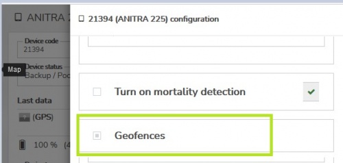
| − | :* | + | :* for configuring GF click the „geofences“ section in the device configuration screen |
| − | + | :** note the geofencing functionality was significantly reshaped and only devices with device firmware updated to the latest versions can use this feature. | |
| − | :[[File: | + | :** if you do not see the „geofences“ section in your configuration screen please consult us if your device can possibly use this functionality |
| − | + | :[[File:GF_in_config_screen.JPG|500px]] | |
| − | |||
| − | |||
| − | |||
| − | |||
| − | |||
| − | |||
| − | |||
| − | |||
| − | |||
| − | |||
| − | |||
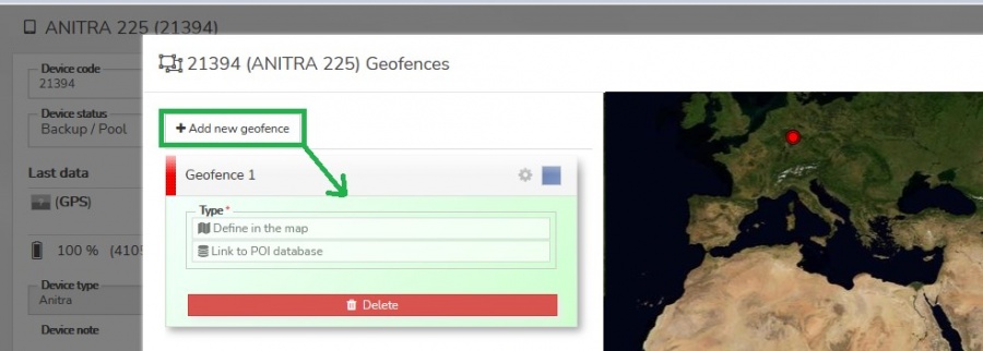
| + | :* a dedicated screen showing list of GF on the left side and a map of those on the right | ||
| + | :* a new GF can be created using the „Add new geofence“ button | ||
| + | :[[File:GF_new_geofence.JPG|900px]] | ||
| − | + | ==Geofence definition== | |
| − | + | :* consists of | |
| − | + | :** spatial definition (Latitude, Longitude, Radius{range, and Altitude) | |
| − | + | :** modified behavior configuration for the geofence | |
| − | |||
| − | + | :* a spatial definition can be done in two ways | |
| − | + | :**either manually in the map - „Define in the map“ option | |
| − | + | :***set the center and drag a radius in the map | |
| + | :***proceed to behavior definition | ||
| + | :**or using POI group – „Link to POI database“ option | ||
| + | :***list the existing POI group (note this requires you to have defined some POIs and POI groups previously – see the dedicated section of Anitra documentation | ||
| + | :***latitude and longitude definitions are used from POIs in the group and you only need to define the radius valid for all the POIs | ||
| + | :***save and proceed to behavior definition | ||
| − | A | + | ==Geofence behavior== |
| − | + | :* A modified geofence behavior is defined in the Geofence behavior screen. A subset of configuration parameters can be overridden within the geofence | |
| − | + | :** day/night data collection interval | |
| − | + | :** activity and speed triggering | |
| − | + | :** radio buoy activation | |
| − | + | :** communication while entering{leaving the geofence | |
| − | + | :[[File:GF_behavior.JPG|900px]] | |
| − | |||
| − | + | :* definition | |
| − | + | :** a simplified configuration screen to manage geofence parameters is shown | |
| − | + | :** currently valid configuration is displayed as a background | |
| − | + | :** GF parameters overriding standard configuration can be set and saved | |
| − | + | :** a similar editing logic as for standard configuration is implemented here – i.e draft modifications (blue) and already saved values (red) | |
| − | + | :*** get rid of any blue changes using blue crosses or simply closing the screen without saving the values | |
| − | + | :*** remove all red (saved) modifications using red crosses and resaving the screen | |
| − | notes on navigation | + | ==notes on navigation== |
• Select the GF in the left list of in the map to locate it in the map nad vice versa | • Select the GF in the left list of in the map to locate it in the map nad vice versa | ||
• Geofences can have following states | • Geofences can have following states | ||
Revision as of 22:21, 3 October 2021
Geofences (GF) modify a standard device behavior based on the geographic location
Contents
Specifics of Anitra geofencing
- tailored for very advanced geofencing tasks on top of POI databases with even many thousands of items (e.g. database of past poisoning places, wind turbines, dangerous power pylons, etc)
- a dynamic geofence synchronization (when moving the tag synchronizes 100 closest geofence instances)
- geofences defined by circular (or possibly even cylindrical) zones
- working with circles allows resolving conflicts for overlapping geofences (as the closest, the smallest)
- altitude definition enables 3D geofencing (when higher it is considered as outside of geofence)
Geofence creation
- for configuring GF click the „geofences“ section in the device configuration screen
- note the geofencing functionality was significantly reshaped and only devices with device firmware updated to the latest versions can use this feature.
- if you do not see the „geofences“ section in your configuration screen please consult us if your device can possibly use this functionality
- for configuring GF click the „geofences“ section in the device configuration screen

- a dedicated screen showing list of GF on the left side and a map of those on the right
- a new GF can be created using the „Add new geofence“ button

Geofence definition
- consists of
- spatial definition (Latitude, Longitude, Radius{range, and Altitude)
- modified behavior configuration for the geofence
- consists of
- a spatial definition can be done in two ways
- either manually in the map - „Define in the map“ option
- set the center and drag a radius in the map
- proceed to behavior definition
- or using POI group – „Link to POI database“ option
- list the existing POI group (note this requires you to have defined some POIs and POI groups previously – see the dedicated section of Anitra documentation
- latitude and longitude definitions are used from POIs in the group and you only need to define the radius valid for all the POIs
- save and proceed to behavior definition
- either manually in the map - „Define in the map“ option
- a spatial definition can be done in two ways
Geofence behavior
- A modified geofence behavior is defined in the Geofence behavior screen. A subset of configuration parameters can be overridden within the geofence
- day/night data collection interval
- activity and speed triggering
- radio buoy activation
- communication while entering{leaving the geofence
- A modified geofence behavior is defined in the Geofence behavior screen. A subset of configuration parameters can be overridden within the geofence
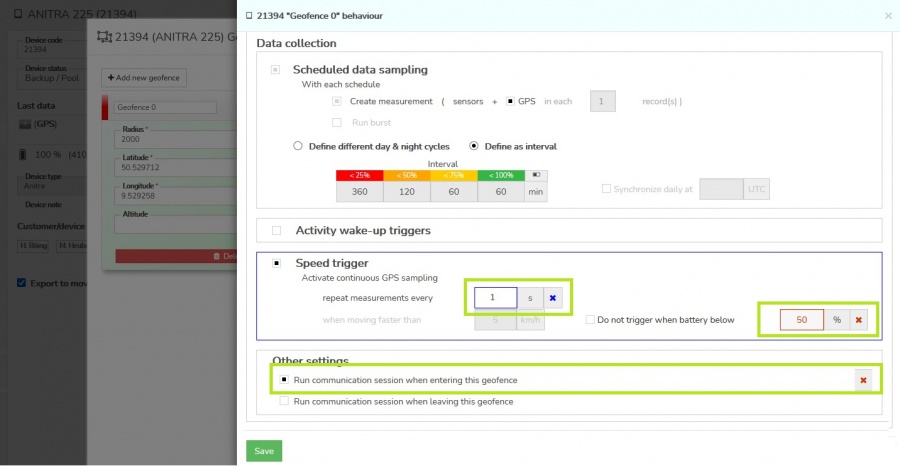

- definition
- a simplified configuration screen to manage geofence parameters is shown
- currently valid configuration is displayed as a background
- GF parameters overriding standard configuration can be set and saved
- a similar editing logic as for standard configuration is implemented here – i.e draft modifications (blue) and already saved values (red)
- get rid of any blue changes using blue crosses or simply closing the screen without saving the values
- remove all red (saved) modifications using red crosses and resaving the screen
- definition
• Select the GF in the left list of in the map to locate it in the map nad vice versa • Geofences can have following states o new: a geofence with spatial definition but no behavior defined yet o inactive/disabled: a complete GF definition ready to be acivated, allows temporary disabling GF and reanabling later when neded o active: only in this state the GF definition is actualy submitted to device ! • you can change the GF states using buttons („save“, „activate“, „disable“, „delete“) – a relevat buttons appear when clicking at the GF in the list o save – saves modified definition o activate – activates prepared definition and submits it to device in next communication session • access GF edit mode double clicking the geofence in the left GF column o you can manuály modify the original spatial definition retyping the values of latitude, Longitude, Radius or Altitude o you can also custom name the geofence o access behavior definition klicking a cog wheel icon o use escape to close „edit mode“
groups