Difference between revisions of "PUBLISHED MAPS"
(→Creating and managing your public maps) |
|||
| Line 37: | Line 37: | ||
:In both locations, the list of existing published maps is shown with the following properties and options available | :In both locations, the list of existing published maps is shown with the following properties and options available | ||
:* '''create''' new map using the "Add map" button | :* '''create''' new map using the "Add map" button | ||
| − | :* '''modify''' existing map using the "EDIT" button. | + | :* '''modify''' existing map using the "EDIT" button. <br>'' Note editing of the map definition later on does not affect the actual URL/HTML of it. Any changes apply to the existing map definition are reflected into all the online instances right away.'' |
:* '''remove''' existing map using the "DELETE" button. <br> ''Note that once removed any previously published map references will stop working ! Make sure you maintain control over where your links were previously used.''<br>[[File:publish_map_projects_maplist.JPG|900px]] | :* '''remove''' existing map using the "DELETE" button. <br> ''Note that once removed any previously published map references will stop working ! Make sure you maintain control over where your links were previously used.''<br>[[File:publish_map_projects_maplist.JPG|900px]] | ||
| Line 44: | Line 44: | ||
:* HTML code: a code ready to be easily embedded into your WEB page or in particular formatted online articles | :* HTML code: a code ready to be easily embedded into your WEB page or in particular formatted online articles | ||
: You can switch between existing language variants (if you defined those in map configuration - see below) and pick the link variant which suits your publication best. Note the distinct URL/HTML while switching "LANGUAGE". | : You can switch between existing language variants (if you defined those in map configuration - see below) and pick the link variant which suits your publication best. Note the distinct URL/HTML while switching "LANGUAGE". | ||
| − | :* URL for particular language variant (e.g. "Spanish"): be used in language variant of your website (e.g. Spanish page) | + | :* URL for particular language variant (e.g. "Spanish"): to be used in language variant of your website (e.g. Spanish page) |
:* "CHOICE": a map with the language switching control in legend - the public map will show language swithing control in legend (the flag symbol) <br>[[File:publish_map_languageSwitchingx.jpg|300px]] | :* "CHOICE": a map with the language switching control in legend - the public map will show language swithing control in legend (the flag symbol) <br>[[File:publish_map_languageSwitchingx.jpg|300px]] | ||
| − | =Editing and | + | =Editing map definition= |
| + | |||
| + | : Map editing screen contains these main components: | ||
| + | :* map filter (top left, red) | ||
| + | :* map definition panel (left, yellow) | ||
| + | :* interactive preview of the final map (right, green)<br>[[File:publish_map_layout.JPG|900px]] | ||
| + | |||
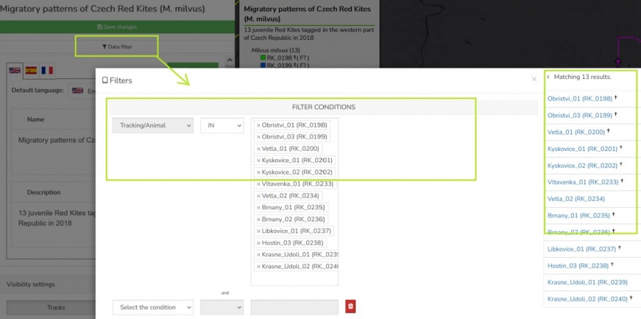
| + | : In the map filter a selection of Animals can be done using a simplified [[Main_Page#FILTERS_.26_SEARCHES:_How_do_I_find_what_I_am_looking_for_.3F |filter functionality]] | ||
| + | : ''Note that any time you modify the filter the whole map definition is saved and preview reloaded''<br> [[File:publish_map_filter.jpg|900px]] | ||
| + | |||
| + | |||
| − | |||
[[File:publish_map_configuration_groups.JPG|900px]] | [[File:publish_map_configuration_groups.JPG|900px]] | ||
Revision as of 10:46, 23 February 2022
Contents
Overview
- A tool tailored to configure simplified and secured live telemetry maps from your full data sets.
- Configured maps are available in form of a link or in form of short HTML code which can be simply added to your web presentation or published on Facebook.
- Map output can be created:
- on top of single organization data
- on top of "project" (i.e. accross more complex data ownership structure)
- Map editor with a live preview is used to configure the map
- Two map modes can be configured:
- map showing the simplified Tracks
- map showing the Last positions only
- For the mode of "Tracks" an Animation can be anabled
- The map configuration includes:
- animal selection
- language localisations (alternative language variants)
- map mode (tracks vs. last position), grouping options, ordering, data filtering (e.g. track simplified to one position a day)
- security features (security delay, zoom restriction, position "rounding")
- presentation and visualization presets (a default map selection, icon/track styles, choice of icons, logos with links, foto gallery, animation enabling)
Creating and managing your public maps
- Public maps can be created using telemetry data owned by the Customer/Organization or data attached to a particular Project with a more complex ownership structure.
- Because of this the map creation and managing functionality is accessible in two distinct places in Anitra
- in the Customer/Organization profile
- in the Project/Group profile
- Depending on the context the Customer or Project admins respectively can manage (create, edit, remove) particular Organization or Project maps
- In both locations, the list of existing published maps is shown with the following properties and options available
- create new map using the "Add map" button
- modify existing map using the "EDIT" button.
Note editing of the map definition later on does not affect the actual URL/HTML of it. Any changes apply to the existing map definition are reflected into all the online instances right away. - remove existing map using the "DELETE" button.
Note that once removed any previously published map references will stop working ! Make sure you maintain control over where your links were previously used.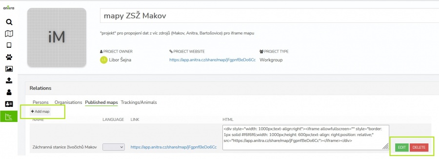

- The map list shows the URL links and HTML code strings ready to be used for map publication
- URL links: for quick link sharing and opening the map in browser or e.g. posting it to your Facebook presentation
- HTML code: a code ready to be easily embedded into your WEB page or in particular formatted online articles
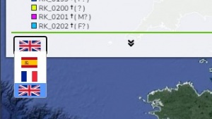
- You can switch between existing language variants (if you defined those in map configuration - see below) and pick the link variant which suits your publication best. Note the distinct URL/HTML while switching "LANGUAGE".
- URL for particular language variant (e.g. "Spanish"): to be used in language variant of your website (e.g. Spanish page)
- "CHOICE": a map with the language switching control in legend - the public map will show language swithing control in legend (the flag symbol)

Editing map definition
- Map editing screen contains these main components:
- map filter (top left, red)
- map definition panel (left, yellow)
- interactive preview of the final map (right, green)
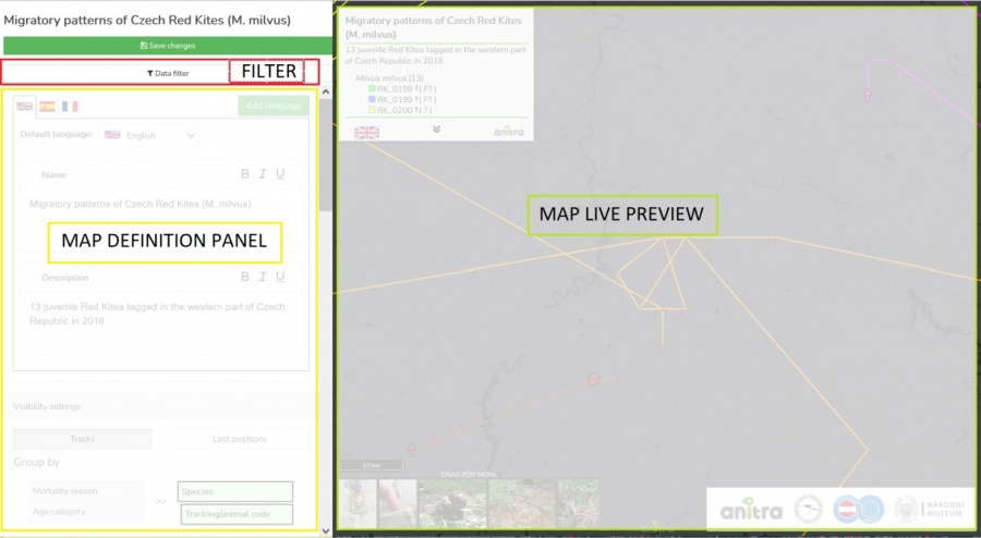

- In the map filter a selection of Animals can be done using a simplified filter functionality
- Note that any time you modify the filter the whole map definition is saved and preview reloaded


The map definition consists of these steps or areas:
- Name and Description
- basic text formatting for Name and Description (italics, bold, underline, and link)
- Language options (the final iframe will show a button with a flag for the possibility of language switching)
- Selection of titles to the legend (Tracking based settings)
- You can select whether to use “TO name” and/or “TO code”
- It is possible to define a color for each Tracking/Animal
- Security settings
- GPS rounding level
- Maximum zoom
- Option to enable/disable photo gallery
- Logos
- Possibility of uploading logos, including a click through to the organization's website
- On the screen "Edit"
- Adjusting settings on the left
- On the right, a preview of the final iframe form is displayed dynamically
- All changes can then be saved by clicking on the button "Save changes"
Other functions of the final iframe
- Fullscreen
- Option to turn on / off only selected trackings in the legend
- The selection in the legend also filters the enabled photo gallery
- Browser remembers your tracking selection
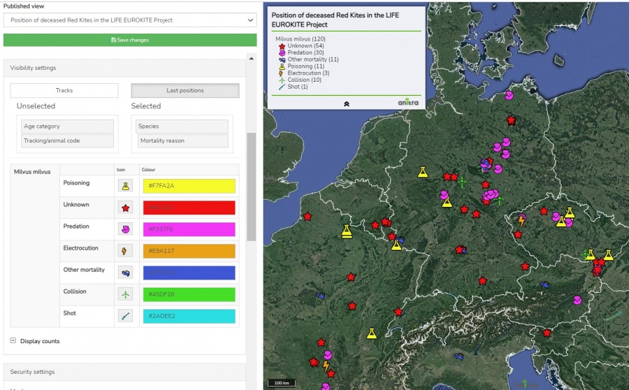
- The legend also shows species, age, and gender
- The legend shows the icon for the death of an individual (if the date of death is filled) and after the mouse movement, the reason for the death (from the field "Mortality reason" - if it is filled in)
Sample published maps
- these sample maps are showing some of the features
- map with tracks and gallery: https://app.anitra.cz/share/map/5d2e379ed6f9c
- map of last positions with categories: https://app.anitra.cz/share/map/5f1a97bb13ba5